 West Coast Tides - CA to Wash

West Coast Tides - CA to Wash
free
not available
Entire West Coast U.S.A. tide charts on a simple to use, highly accurate satellite map. SIMPLE TO USE, NO SPAM ADS...100% AD FREE.
Covers these tide charts: California tides, Oregon tides, and Washington State tides. Oregon tides as well as California and Washington State include some rivers as far inland as NOAA has reporting tidal stations. NO ADS and easy to use.
Optional PRO subscription service for users to access complete LIVE weather satellite and forecasts from the OFFICIAL National Weather Service within the app. Sunrise/Sunset and Moonrise/Moonset and Moon Illumination and Age.
NEW! Added ability to share tide charts via Facebook or Email.
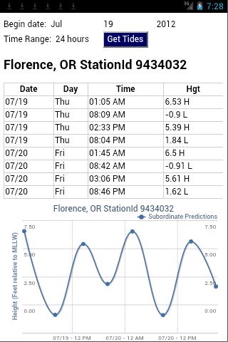
Easy to Use, advanced tide graphs allow for you to judge the level of water movement for optimal fishing between high and low tide.
Ability to forecast tides from NOAA by setting date and period for any of the tidal stations for the entire West Coast of the U.S.: California tides, Oregon tides, and Washington State tides.
When GPS is available we auto-locate your position and zoom to the map for surrounding NOAA tide stations near you.
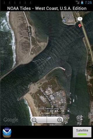
Included is the ability to zoom and view satellite imagery for fishing ground characteristics to compare with tide movement.
Simply the easiest way to locate Oregon tide tables, California tide tables, and Washington State tide tables directly from NOAA.
Points of interest include entire NOAA tides for: Oregon Tides, Washington Tides, California Tides
Covers these tide charts: California tides, Oregon tides, and Washington State tides. Oregon tides as well as California and Washington State include some rivers as far inland as NOAA has reporting tidal stations. NO ADS and easy to use.
Optional PRO subscription service for users to access complete LIVE weather satellite and forecasts from the OFFICIAL National Weather Service within the app. Sunrise/Sunset and Moonrise/Moonset and Moon Illumination and Age.
NEW! Added ability to share tide charts via Facebook or Email.
Easy to Use, advanced tide graphs allow for you to judge the level of water movement for optimal fishing between high and low tide.
Ability to forecast tides from NOAA by setting date and period for any of the tidal stations for the entire West Coast of the U.S.: California tides, Oregon tides, and Washington State tides.
When GPS is available we auto-locate your position and zoom to the map for surrounding NOAA tide stations near you.
Included is the ability to zoom and view satellite imagery for fishing ground characteristics to compare with tide movement.
Simply the easiest way to locate Oregon tide tables, California tide tables, and Washington State tide tables directly from NOAA.
Points of interest include entire NOAA tides for: Oregon Tides, Washington Tides, California Tides